
Fate of Jakarta's giant sea embankment as a flood barrier
The placard, bearing the Dutch words, mirrors the confidence of the Dutch people over the embankment Oosterscheldekering, one of the 13 dykes and giant dams built in the Land of the Windmills, after the 1953 North Sea flood, a major flood caused by a heavy storm that occurred on the night of Saturday, January 31, 1953.
As recorded in history, the heavy storm caused the water to overflow and inundate several countries, such as the Netherlands, Belgium, and Great Britain.
In the Netherlands, massive flooding covered an area of 1,365 square kilometers, killing 1,835 people, and forcing over 70 thousand people to flee. The flooding also damaged 47,300 buildings, of which 10 thousand buildings were totally destroyed.
This tragedy led the Dutch government to establish the Delta Commission to study the causes and effects of floods. Subsequently, the government drew up a plan to build Deltawerken, which is a construction project for 13 giant dykes and large dams to protect several areas of the Netherlands from the overflowing North Sea.
Deltawerken's largest dam is Oosterscheldekering, which is some nine kilometers long.
Initially, Oosterscheldekering was designed as a giant closed embankment, but after the local residents protested, the government made an open-close access gate along four kilometers.
The gate is usually left open though can be closed based on weather conditions. An open-close system facilitates conservation of the marine ecosystem while also enabling fishermen to continue with their fishing processes, while the land is protected from the sea water.
Oosterscheldekering, built since 1960, was finally opened by Queen Beatrix on October 4, 1986, with her famous speech, "De stormvloedkering is gesloten. De Deltawerken zijn voltooid," or meaning flood barrier has been closed. Deltawerken has been completed.
However, The Netherlands has never again witnessed a great flood tragedy such as that in 1953. The American Society of Civil Engineers has named Oosterscheldekering as one of the Seven Wonders in the Modern World.
NCICD
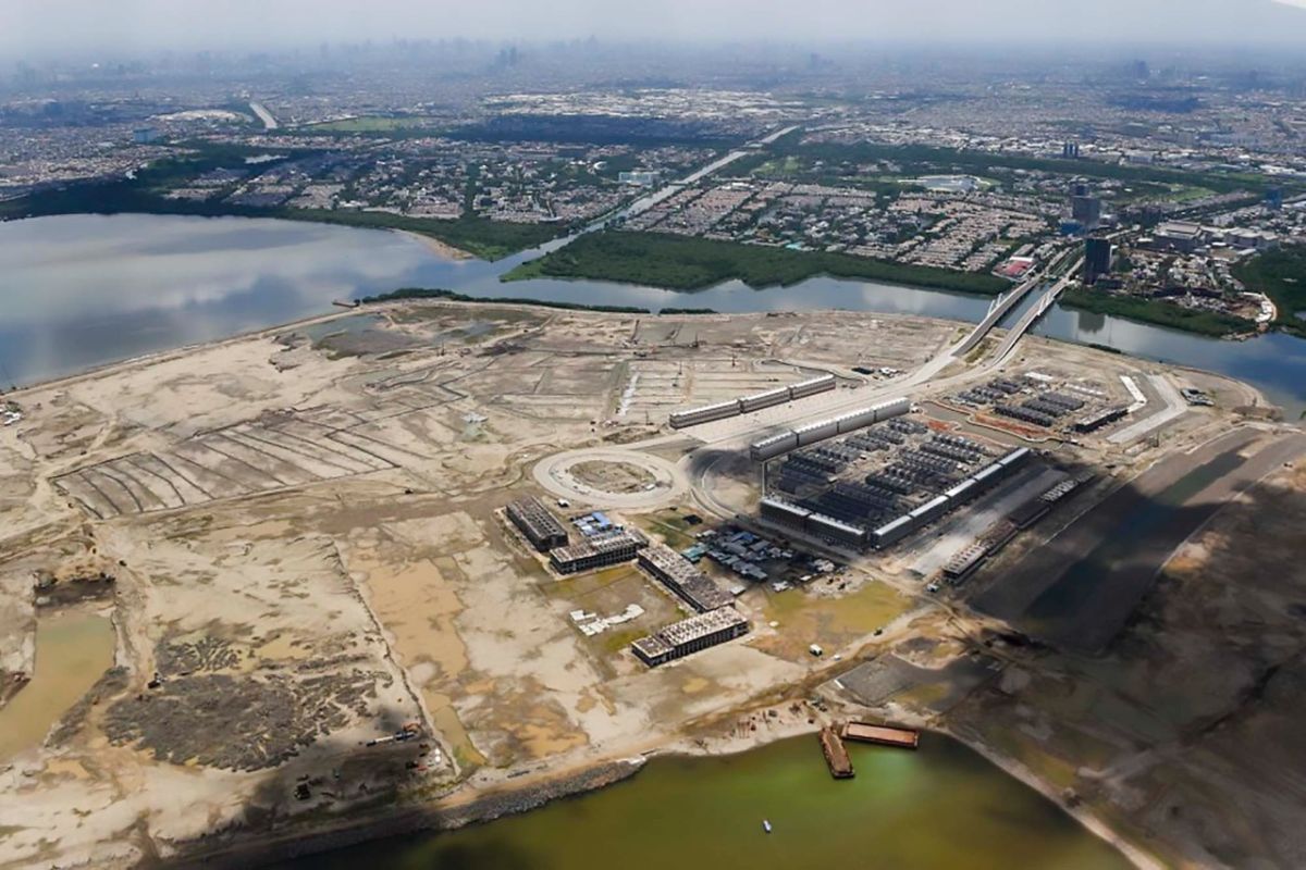
What about Jakarta? The capital of Indonesia, as quoted from the official website of the Committee for the Acceleration of Priority Infrastructure Provision, stated that the National Capital Integrated Coastal Development (NCICD) included the construction of a giant embankment in the northern part of Jakarta Bay as a means of protecting the capital city from flooding.
The site states, of the three phases of the mega project, Phase A is focused on improving the existing coastal protection, specifically by strengthening and developing coastal embankments that are 30 kilometers long and the construction of 17 artificial islands in Jakarta Bay.
The launch of the first phase was conducted in early September 2014, while the construction was planned in early 2016.
However, the DKI Jakarta provincial government has revoked the principle permit for the reclamation island in Jakarta Bay that simultaneously ensures the termination of reclamation work on the 13 islands that have not yet been built and the four other islands that have been completed will be managed in public interest.
DKI Jakarta Provincial Governor Anies Baswedan stated at the Jakarta City Hall on September 26, 2018, that the decision was taken after obtaining a recommendation from the North Coast Management Coordinating Board (BKP-Pantura).
"From the results of the recommendation, we ensure the 13 islands that have not been built will be terminated. The termination not only means the workmanship that is stopped but also overall, as the principle and implementation licenses are also revoked. As for the four existing islands, it will be managed in the public interest," Baswedan stated.
Nevertheless, Baswedan noted that the Jakarta government had continued to support economic development and property actors while ensuring that spatial management and utilization took into account environmental aspects and coastal empowerment.
The holders of these principle licenses did not fulfill the required licensing obligations, specifically design, environmental impact analysis, and others. Until the verification process was conducted, the principle permit was left vacuum by the permit holder until the Jakarta Government finally decided to revoke the permit given to developers.
Remediation
Meanwhile, Minister of Public Works and Public Housing (PUPR) Basuki Hadimuljono stated on several occasions that the NCICD program was not merely focused on flood control but rather the remediation or improvement of Jakarta's environment that had already exceeded its carrying capacity, so that it could be developed in future.
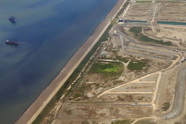
During the 2014-2018 period, the Ministry of Public Works and Housing had built beach and river embankments as the initial phase. In 2014, construction was conducted in Pluit for the Phase I embankment of length 75 meters.
Development continued for Phase II, which was 4.5 km long and comprised two packages, during the 2016-2018 period.
The Government of the Republic of Indonesia and the Kingdom of the Netherlands agreed to strengthen synergy for cooperation in the field of water management that had existed since long and continued to develop, one of which was construction of the Jakarta sea dike.
Earlier, Secretary General of the Ministry of Public Works and Public Housing (PUPR) Anita Firmanti stated that joint monitoring and evaluation was conducted to ensure the MoU between Indonesia and the Netherlands over this matter was conducted through the Joint Steering Committee (JSC) in order to decipher achievements, constraints, and follow-up.
She stated that the annual JSC meeting, attended by secretaries general of the two countries' ministers, was also held. On November 13-14, 2018, the JSC meeting was held in The Hag, Netherlands.
From the results of the discussion presented at the plenary meeting, the project, already in the implementation phase, specifically the construction of a part of the Jakarta sea embankment of 4.5 kilometers, had been undertaken.
Construction of the Jakarta sea dike was part of the master plan of the National Capital Integrated Coastal Development (NCICD) aimed at reducing the risk of floods and tidal floods, as well as preventing a decline in the surface of Jakarta's groundwater.
The NCICD activity was a collaboration between three countries: the Governments of Indonesia, the Netherlands, and South Korea.
Overall, the NCICD deep-sea dike project of phase A reached 62.62 kilometers, with the strengthening of the sea dike in critical areas along 46.58 kilometers. From this area, the initial work was divided into three: specifically the Ministry of PUPR, along 19.48 kilometers; the Provincial Government of DKI, 11.5 kilometers; and the private sector, 15.5 kilometers.
From this division, the Ministry of PUPR has completed 4.5 kilometers; the DKI Provincial Government, 2.7 kilometers; while the private sector, only 2.1 kilometers. However, the private sector resigned, so the remaining work on strengthening the sea dike is planned to be completed by the Ministry of Public Works and Public Housing (PUPR) and the Provincial Government of DKI.
Polder system
Meanwhile, several hydrological experts from the Gadjah Mada University (UGM) believe that applying a polder system would become the main solution for flood mitigation in DKI Jakarta, in addition to river normalization and drainage cleaning.
"I think it is the only possible way. The polder system is a way to deal with floods in Jakarta," Prof. Bambang Triatmodjo, a hydrologist from Gajah Mada University, had stated during a press conference at the UGM Campus, Yogyakarta, on Monday (Jan 6).
A polder system, among others, was applied in the Pantai Indah Kapuk Housing, North Jakarta. He noted that the polder system was able to keep the elite housing, two meters below sea level, protected from potential flooding.
Hence, Bambang stressed on the need for the Jakarta government to apply a polder system, which is a combination of dykes and pumps at several points, adjusting to the inundation map from the local public works department.
He believes that it was difficult to prevent the potential for flooding in Jakarta without the system accompanied by river normalization and drainage cleaning. This was especially in the event of very heavy rainfall as that experienced from December 31, 2019, to January 1, 2020, that had reached 377 millimeters per day.
UGM water resources engineering expert, Prof. Budi Santoso explained, as applied in the Netherlands, the polder system was to build embankments around the city. The water in the embankment was collected and then pumped out and flowed into the sea.
He stated that the system was usually implemented in a place where the groundwater level was lower than the sea level.
Pewarta : M Razi, Azis Kurmala
Editor:
Sukardi
COPYRIGHT © ANTARA 2026